


You may also like
-
Ancient map of Spain Poster
Carl Diercke · 1905 · Detailed Iberian Peninsula vintage print with regional borders and coastal waters in soft beige and blue
Poster from €9 · Framed from €16
Regular price From €6,00Regular price -
Spain & Portugal Poster
Bartholomew John George · 1922 · Detailed Iberian Peninsula map poster with coastal outlines, borders, and classic atlas typography
Poster from €9 · Framed from €16
Regular price From €6,00Regular price -
Antique map of Italy Poster
Institute of Liepzig · 1887 · Classic Italy map poster with crisp borders, islands, and dense geographic labeling
Poster from €9 · Framed from €16
Regular price From €6,00Regular price -
Antique map of Mexico Poster
Institute of Liepzig · 1887 · Detailed Mexico vintage print featuring crisp borders and classic atlas typography
Poster from €9 · Framed from €16
Regular price From €6,00Regular price


-

"Very nice Posters. The quality is amazing and we received it very quickly !"
-

"A shop to visit absolutely. Huge selection of posters. We spent more than an hour there !"
-

"Perfect to find gift. Price are very good. An they can frame and pack it on site"


About the Artist
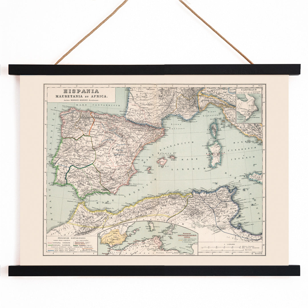
Heinrich Kiepert was a prominent nineteenth-century German cartographer renowned for his expertise in historical geography, particularly his detailed maps of the ancient world. His scholarly approach and commitment to accuracy made his atlases essential tools for universities and schools seeking reliable visual references during a period of growing academic interest in antiquity.
Kiepert’s careful research and precise draughtsmanship shaped how generations visualized the classical era. His work bridged the gap between academic rigor and accessible design, making complex historical information both understandable and visually engaging.
The Artwork
This map of Hispania, created in the mid-1800s, illustrates the Iberian Peninsula as it was organized under Roman provincial rule. Produced at a time when the study of Latin and archaeology flourished, such maps helped scholars and students connect ancient texts to real-world geography, transforming distant place names into tangible locations.
By including adjacent regions of the western Mediterranean, the map situates Hispania within the broader context of Roman imperial networks, highlighting routes, borders, and spheres of influence. It reflects the era’s fascination with how empires structured territory and identity, offering a window into the administrative logic of the ancient world.
Style & Characteristics
This fine art print features crisp, precise linework and densely labeled provinces, each distinguished by subtle hand-applied washes of color. The composition balances open areas of light paper with intricate coastlines, borders, and interior details, creating a sense of clarity and order.
Touches of green, red, blue, and yellow accentuate the provinces without overpowering the map’s refined typography. The overall effect is calm and scholarly, embodying the elegance of antique atlas design and the legibility prized by collectors of historical maps and classic art prints.
In Interior Design
This vintage map print is well suited to a study, library, hallway, or living room where an appreciation for history and travel is welcome. Its detailed presence complements traditional interiors, mid-century furnishings, and minimalist spaces seeking a focal point with depth.
Pair it with warm whites, muted greens, or natural linens, or echo its color accents with subtle blue or red decor. It also integrates seamlessly into a gallery wall and gains sophistication with simple frames in walnut, black, or antique gold.